
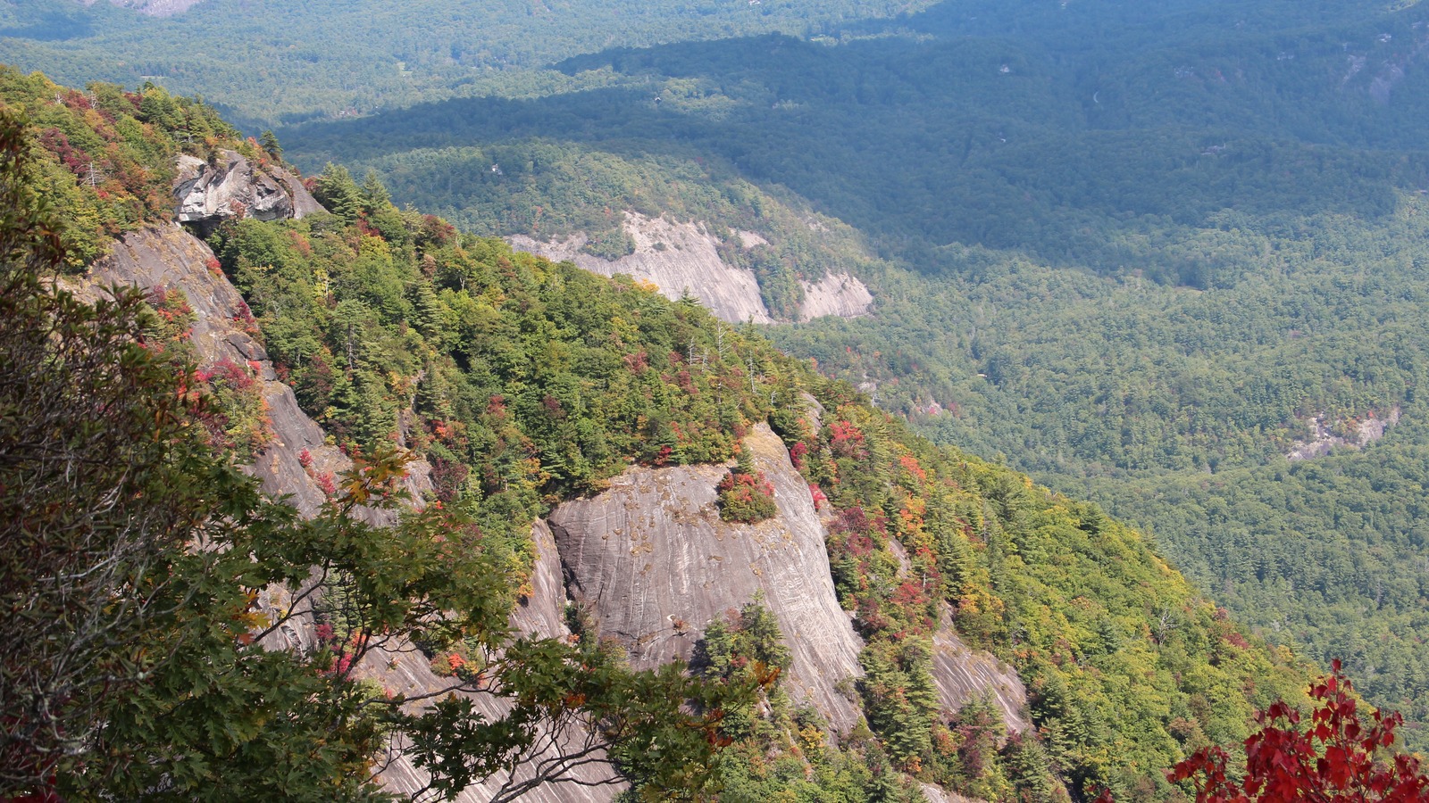
Highlands is a town of barely a thousand permanent residents sitting at about four thousand one hundred feet on a plateau in the Nantahala National Forest, which makes it one of the highest incorporated towns in the eastern United States and gives it a climate the lowlands do not share. Nearly everything on this list is a waterfall, a cliff or a gallery within twenty minutes of Main Street, so plan by road rather than by day, working the gorge west of town on one outing and the Cashiers side east on another.
The top 14, ranked
Ranked by how consistently each pick appears across official Highlands sources, the local destination marketing organization, and recent independent roundups.
- Top pick
 #1Best for Views · #1 of 14
Whiteside Mountain
ParkEast on US 64 toward CashiersOpen in daylight through the year with a small national forest day use fee, and closed to nesting areas of the cliff in spring when peregrines are on the ledgesTicketedThe sheer face on the ridge between Highlands and Cashiers carries some of the tallest cliffs in the eastern United States, and a loop of about two and a half miles climbs to a rim trail that runs along the top of them. The gain is a little over five hundred feet, the drop off the edge is unfenced in places, and the views run south into Georgia and South Carolina.
Local tipWalk the loop counterclockwise so the steep section comes first and the cliff top rim is the long, level reward.
- Top pick
 #2Best for Families · #2 of 14
Dry Falls
ParkUS 64 west and the Cullasaja GorgeOpen in daylight year round with a parking fee at the lot, and the stairs occasionally closed after ice or rockfallTicketedAn eighty foot curtain of the Cullasaja River pours off an overhanging bluff three miles west of town, and a paved path curls in behind it so that visitors stand between the rock and the falling water. There is a viewing platform reachable straight from the parking area for anyone who cannot manage the stairs, and the walk down and back is only about two tenths of a mile.
Local tipThe walkway stays slick even in dry weather because of the spray, so treat the handrail as compulsory rather than decorative.
- Top pick
 #3Best for Walking · #3 of 14
Main Street and Downtown Highlands
Neighborhood LandmarkMain Street and the town rimShops keep full daytime hours through the summer and autumn, with many on reduced days or closed altogether in the depth of winterFree with paid optionsFour short streets, Main, Spring, Fourth and Carolina Way, hold a density of galleries, outfitters, bookshops and independent boutiques that no town of this size would normally support, sustained by a summer population many times the winter one. The whole grid is flat and walkable, and the plateau's climate means a summer afternoon here is pleasant rather than endured.
Local tipPark once at the edge of the grid and stay on foot, because the streets are short and the parking turns over slowly in season.
-
4Best for Art · #4 of 14
The Bascom
MuseumMain Street and the town rimGalleries open most days with one or two closed days each week, and the grounds accessible more widely in daylightFree with paid optionsA visual arts center on six acres of former horse farm just off the edge of town is entered across an eighty seven foot covered bridge, with three galleries running about ten exhibitions a year and a restored barn working as a ceramics studio. Exhibitions are free, and a sculpture and nature trail loops through native planting, a brook and a small waterfall behind the buildings.
Local tipThe grounds and sculpture trail are open beyond gallery days, so the walk is still worth the stop if the exhibitions are between shows.
-
5Best for Families · #5 of 14
Highlands Botanical Garden and Nature Center
GardenMain Street and the town rimGarden trails open in daylight through the year, with the nature center on a seasonal schedule weighted to the warm monthsFree with paid optionsThe Highlands Biological Station, a field research campus of Western Carolina University, keeps a botanical garden of more than five hundred native plant species on trails running through forest, past a pond and along creeks a few minutes from Main Street. The attached nature center handles the public side with exhibits, salamanders and children's programs, and the garden itself is free to walk.
Local tipThis plateau holds one of the densest salamander populations anywhere, and the nature center is the easiest place to actually see them.
-
6Best for Views · #6 of 14
Sunset Rock and Sunrise Rock
ParkMain Street and the town rimOpen at any hour with no gate or fee, and busiest in the half hour before sunset through the summer and leaf seasonsFreeA half mile walk up a gravel road from beside the nature center reaches a natural amphitheater of granite slabs looking west over the rooftops of Highlands, which is the town's own sunset viewpoint. A shorter spur from the same track leads to Sunrise Rock facing the other way, and the round trip runs to about a mile and a half with modest climbing.
Local tipTake a torch for the walk back down, because the gravel track is unlit and the descent takes longer in the dark than people expect.
-
 #7Best for Quick stops · #7 of 14
Bridal Veil Falls
ParkUS 64 west and the Cullasaja GorgeVisible and accessible at any hour from the roadside, with the drive behind loop closed when ice or rockfall makes it unsafeFreeA thin hundred and twenty foot fall drops beside US 64 about two and a half miles west of town, over a loop of the old roadbed that cars can still pull through, which makes it one of the few waterfalls in the country you can drive behind. In a hard freeze the spray builds a mound at the base and occasionally locks the whole fall into a column of ice.
Local tipThe pull through is low and narrow, so anything taller than a normal car should stop in the layby and walk the few steps instead.
-
8Best for Hiking · #8 of 14
Glen Falls
ParkThe roads south, 106 and Horse CoveOpen in daylight year round as national forest trail, with the gravel access road rough after stormsFreeThree separate drops of roughly seventy, sixty and fifteen feet come one after another down the East Fork of the Overflow Creek, reached by a trail of about two miles round trip with viewing decks at each stage. The first deck sits half a mile in, so a short version works, and the whole descent runs off a gravel road two miles down Highway 106.
Local tipThe trail loses height steadily on the way in, so anyone turning back at the first deck saves most of the climbing.
-
 #9Best for Scenic drives · #9 of 14
The Cullasaja Gorge and Bust Your Butt Falls
ParkUS 64 west and the Cullasaja GorgeThe road is open at all hours through the year, with the swimming holes usable only in warm weather and unsafe when the river runs highFreeWest of town US 64 clings to the wall of the Cullasaja Gorge for eight miles down toward Franklin, dropping past a run of falls, pull offs and swimming holes including the natural rock slide known locally as Bust Your Butt. It is a slow, narrow road with a genuine drop on one side, and the gorge itself is the attraction rather than any single stop on it.
Local tipDrive the gorge downhill toward Franklin, because almost every pull off is on the right in that direction and safe to reach.
-
10Best for Families · #10 of 14
Highlands Aerial Park
Family AttractionThe roads south, 106 and Horse CoveRuns through the year on booked departures, weather permitting, with the fullest timetable in the warm monthsTicketedA zip line course at Scaly Mountain, fifteen minutes down Highway 106, runs eight lines across a mountain cove at heights up to about two hundred and fifty feet, with a gentler treetop adventure course of bridges and platforms alongside it. There is also a giant swing, a tree climb and guided off road tours of the property.
Local tipMost activities take children from about five upward, but the height and weight limits differ course by course, so check before booking a whole family.
-
 #11Best for Summer · #11 of 14
Sliding Rock at Whiteside Cove
ParkEast on US 64 toward CashiersUsable only in warm weather with the water low, and hazardous whenever the creek is running high after rainFreeA smooth sheet of rock on Whiteside Cove Road above Cashiers carries a shallow creek down into a pool deep enough to land in, and generations have used it as a natural slide. The parking is a small gravel patch past the bridge, the walk in is a matter of yards, and the flat rock beside the pool works as a picnic and sunbathing spot.
Local tipCheck the depth of the pool by getting in before anyone slides, because the level shifts with the season and the rock is unforgiving.
-
12Best for Evenings · #12 of 14
Highlands Performing Arts Center
Music VenueMain Street and the town rimProgramming runs through the year with the heaviest concentration in summer, and the box office keeps limited daytime hoursTicketedThe plateau's main auditorium hosts three resident companies, a theater company, a long running chamber music festival shared with Cashiers, and a community players group, alongside touring performers. It also carries satellite broadcasts of opera and London theater, which gives a town of this size a program that would suit somewhere twenty times larger.
Local tipThe chamber music festival runs across a concentrated summer season and sells out locally, so book those dates before arriving.
-
 #13Best for History · #13 of 14
Highlands Historic Village and Museum
MuseumMain Street and the town rimOpen on a seasonal schedule of selected days through the warmer half of the year, with shorter Sunday afternoonsDonation suggestedThe historical society keeps three buildings on North Fourth Street, the 1877 Prince House, a museum and archive, and a canvas walled sanatorium tent from the years when people came up here to breathe the mountain air. Together they explain how two land speculators drew lines on a map in 1875 and founded a town on an empty ridge.
Local tipThe society also runs guided walking tours of the older streets, which make far more sense of the town than the museum alone.
-
 #14Best for Outdoors · #14 of 14
The Chattooga Loop and the Bartram Trail
ParkThe roads south, 106 and Horse CoveOpen in daylight year round with no fee, and the access road slow going or impassable after ice and heavy rainFreeDown Horse Cove Road and along Bull Pen Road, an iron bridge crosses the upper Chattooga River where a loop of about one and three quarter miles follows the water, climbs an old logging road and comes back out on the road. This is the headwater section of the river, quiet and rocky, and the long distance Bartram Trail runs through the same country.
Local tipBull Pen Road is gravel and slow, so allow twenty minutes for the last few miles rather than judging by the distance.
Where things cluster
Highlands works as a walkable center with three roads leading out of it, and the roads matter more than the days.
- Main Street and the town rimMain, Spring, Fourth and Carolina Way hold the galleries and shops, with the arts center, the botanical garden and nature center, the museum village and the auditorium all within a few blocks. The gravel track to Sunset Rock starts from the same edge of town.
- US 64 west and the Cullasaja GorgeWest of town the highway drops into the Cullasaja Gorge and runs eight narrow miles toward Franklin, passing Bridal Veil Falls, Dry Falls and a string of swimming holes. It is the single most concentrated stretch of waterfalls in the area.
- East on US 64 toward CashiersThe road east climbs past the Whiteside Mountain turning and carries on ten miles to Cashiers, with Whiteside Cove Road dropping south off it to the swimming rock. Cashiers has its own shops and lake and works as a half day out.
- The roads south, 106 and Horse CoveHighway 106 runs southwest past the Glen Falls turning to the zip line course at Scaly Mountain, while Horse Cove Road and Bull Pen Road drop southeast to the upper Chattooga. Both turn to gravel quickly.
Make it a day
The gorge, then the town
Drive west out of town first thing and work down the Cullasaja Gorge, stopping at Bridal Veil Falls and walking in behind Dry Falls before the parking fills. Come back for the afternoon on Main Street and at the arts center, then take the gravel track up to Sunset Rock in time for the light going down over the roofs.
West one day, east the next
Give the first day to the gorge road and the town, adding Glen Falls in the afternoon if there is energy left for the climb back up. Use the second to head east for the cliff rim loop on Whiteside Mountain, carry on into Cashiers for lunch and the shops, and drop down Whiteside Cove Road on the way home.
Behind a waterfall and up a zip line
Start behind Dry Falls, which is short, paved and the kind of thing children remember, then look for salamanders at the nature center and walk a loop of the botanical garden. Spend the afternoon on the treetop course at the aerial park down Highway 106, or swap it in high summer for the rock slide out at Whiteside Cove.
Map
Best time to visit
F
M
A
M
J
J
A
S
O
N
D
The elevation is the whole story here. At about four thousand one hundred feet Highlands runs ten to fifteen degrees cooler than Atlanta or the Carolina piedmont, which is why the town fills between June and September while the lowlands swelter, and why summer is the high season rather than something to avoid. It is also one of the wettest places in the eastern United States, so afternoon cloud and rain are normal rather than bad luck, and the waterfalls are correspondingly reliable. October brings the leaves and the year's busiest weekends, while January to March is genuinely quiet, with ice on the trails and a large share of the shops and restaurants shut until spring.
Staying over? Compare hotels in Highlands at Expedia.
Deep Arrival earns a commission when you buy through partner links. It does not change the price you pay.
Highlands things to do FAQ
Parking, timing, cost, and weather answers for a smoother visit.
Is Highlands, North Carolina related to the Scottish Highlands?
No. Highlands is a small town in Macon County in the far southwest corner of North Carolina, founded in 1875 and named for its position on a high plateau in the southern Appalachians. It has no connection to the Highlands of Scotland, to Invergordon or to any Scottish place of a similar name. Every source used for this guide describes the North Carolina town.
Why is Highlands so much cooler than the rest of the South?
Because of how high it sits. The town is at roughly four thousand one hundred feet, among the highest incorporated towns east of the Mississippi, and air temperature drops steadily with elevation. In practice that means summer afternoons in the seventies when Atlanta is in the nineties, cold nights even in July, and real snow and ice in winter. The same elevation and the moisture pushed up against the escarpment give the plateau one of the highest rainfall totals in the eastern United States.
Which waterfall near Highlands can you actually walk behind?
Dry Falls, three miles west of town on US 64. The paved path drops by steps and then curls in behind the eighty foot curtain of water, so you pass between the rock face and the fall itself. Bridal Veil Falls, closer to town on the same road, is the one you can drive behind on a loop of the old roadbed, although the clearance suits ordinary cars rather than anything tall.
How far is Cashiers from Highlands, and is it worth a trip?
Cashiers is about ten miles east on US 64, roughly twenty minutes on a winding road, and the two towns share a plateau, an arts season and a chamber music festival. Cashiers is smaller and more spread out, built around a crossroads rather than a Main Street, with its own shops, a lake and the Whiteside Cove side roads. Whiteside Mountain sits almost exactly between them, so it is easy to combine.
Do many places in Highlands close in winter?
Yes, more than visitors expect. The town's economy runs on a summer and autumn population many times the winter one, so a significant share of shops, galleries and restaurants either close entirely or drop to a few days a week from January into March. The waterfalls and trails stay open and are at their most dramatic in a freeze, but roads and gravel access tracks ice over and the gorge highway can be genuinely difficult.
Do you need a car in Highlands?
For the town itself, no. Main Street, the arts center, the museum village, the botanical garden and the trailhead for Sunset Rock are all within walking distance of each other. Everything else, including every waterfall except a roadside glimpse of Bridal Veil, needs driving, and there is no public transport on the plateau. Several trailheads sit at the end of gravel roads that are slow in any vehicle.
Keep planning
Use these nearby guides to extend your Highlands trip with a different pace and a clear next stop.
Hero image: Whiteside Mountain, photograph by Thomson200, CC0, via Wikimedia Commons. Cropped to 16:9. Image credits. #1 Whiteside Mountain: Thomson200, CC0, via Wikimedia Commons. #2 Dry Falls: w_lemay, CC BY-SA 2.0, via Wikimedia Commons. #3 Main Street and Downtown Highlands: Warren LeMay, CC0, via Wikimedia Commons. #7 Bridal Veil Falls: w_lemay, CC BY-SA 2.0, via Wikimedia Commons. #9 The Cullasaja Gorge and Bust Your Butt Falls: Jan Kronsell, CC BY-SA 4.0, via Wikimedia Commons. #11 Sliding Rock at Whiteside Cove: VeeDrummer, CC BY-SA 3.0, via Wikimedia Commons. #13 Highlands Historic Village and Museum: Warren LeMay, CC0, via Wikimedia Commons. #14 The Chattooga Loop and the Bartram Trail: Dallas Epper, CC BY-SA 3.0, via Wikimedia Commons.